


was I imagining this?
was I imagining this?
I know i'm leaving myself open to a few witty replies but can anybody remember a particularly unusual cloud formation over the Albox/Oria area a few months back - they looked just like button mushrooms I wish that I had had a camera with me - I can find nothing on the net - it was a very clear early evening.

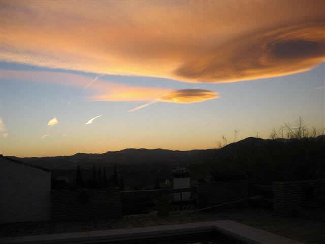
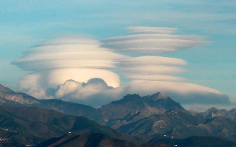
Yes they are Lenticular clouds, fascinating aren't they! They are caused by the downdraft and updraft of air, when it reaches the cooler air, it turns into clouds. These types of cloud are only found around mountain areas. People have often mistaken them for spaceships. The word for Lenticular comes from the word lense

-
Alan-LaCala
- Resident
- Posts: 1103
- Joined: Wed Dec 01, 2004 8:36 am
- Location: La Cala de Mijas
Hi to all who replied and thank you - I had picked up some info on Lenticular clouds on the net before I posted my question but the descriptions and photos did'nt really show the true mushroom formation - it was a very clear evening and from memory it was a prelude to a bad storm later that night, as with Alan's photo though there appeared to only be about six or seven of these formations in the sky.
Once again thank you all for your replies.
regards Mikeyj.
Once again thank you all for your replies.
regards Mikeyj.
IMHO they are very unlikely to have been lenticular clouds as those are associated with strong winds coming down mountains (e.g Fohn or Chinook). Not likely to be ever seen in Southern Andalusia as you would need a very strong wind from the north and we usually have low pressure to the north so winds here tend to be either SE or SWerlies. I would say they were anvil clouds (sometimes called hammer clouds) which are cumulonimbus towering things caused by a strong updraugh and predict a storm brewing. I'm sure there'll be pics in google to check.
-
chicdiz
- Andalucia.com Amigo
- Posts: 60
- Joined: Mon Oct 11, 2004 7:05 pm
- Location: Chiclana de la Frontera
Alan-LaCala wrote:Some terrific pictures on this site.
http://pic1.funtigo.com/valuca?g=25544746&cr=
Alan
thanks Alan for these wonderful marvels of nature.

-
El Cid
- Andalucia Guru
- Posts: 16079
- Joined: Sun Oct 24, 2004 10:42 pm
- Location: La Herradura, Costa Tropical, Granada
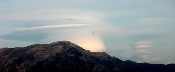
I have seen these clouds on the coast a couple of times. They are certainly not anvil clouds - they are quite different.lis48 wrote:IMHO they are very unlikely to have been lenticular clouds as those are associated with strong winds coming down mountains (e.g Fohn or Chinook). Not likely to be ever seen in Southern Andalusia as you would need a very strong wind from the north and we usually have low pressure to the north so winds here tend to be either SE or SWerlies. I would say they were anvil clouds (sometimes called hammer clouds) which are cumulonimbus towering things caused by a strong updraugh and predict a storm brewing. I'm sure there'll be pics in google to check.
As for wind direction, a low over central or northern Spain will give SW winds but never give SE winds. Northerly winds where we are on the Granada coast are common in winter. They come down from the mountains at night and in early morning. The strongest winds we have experienced were from the north at nearly 90kph (force 10+).
Sid
I read into the above that Mikey had dismissed the lenticular cloud theory hence I suggested the anvil cloud idea because those are very common here. When studying meteorology at university I was always told that lenties were a rare phenomenon over Spain. Glad to see your pic Grouser and clearly the lecturers were mistaken.photos did'nt really show the true mushroom formation
a low over central or northern Spain will give SW winds but never give SE winds
Sid, I never said that. I used the word "lower" not "a low" and obviously lower pressure to the north will mean more southerly winds whether they be SE or SW!
-
El Cid
- Andalucia Guru
- Posts: 16079
- Joined: Sun Oct 24, 2004 10:42 pm
- Location: La Herradura, Costa Tropical, Granada
Sorry, but you did say low - not lower - hence my comments.lis48 wrote:Sid, I never said that. I used the word "lower" not "a low" and obviously lower pressure to the north will mean more southerly winds whether they be SE or SW!
Most of the time the winds are either East or West, there usually isn't a lot of South in them due to the mountain ranges on either side funnelling them through the gap.
Sid
Who is online
Users browsing this forum: No registered users and 46 guests